Lesson Plan Overview
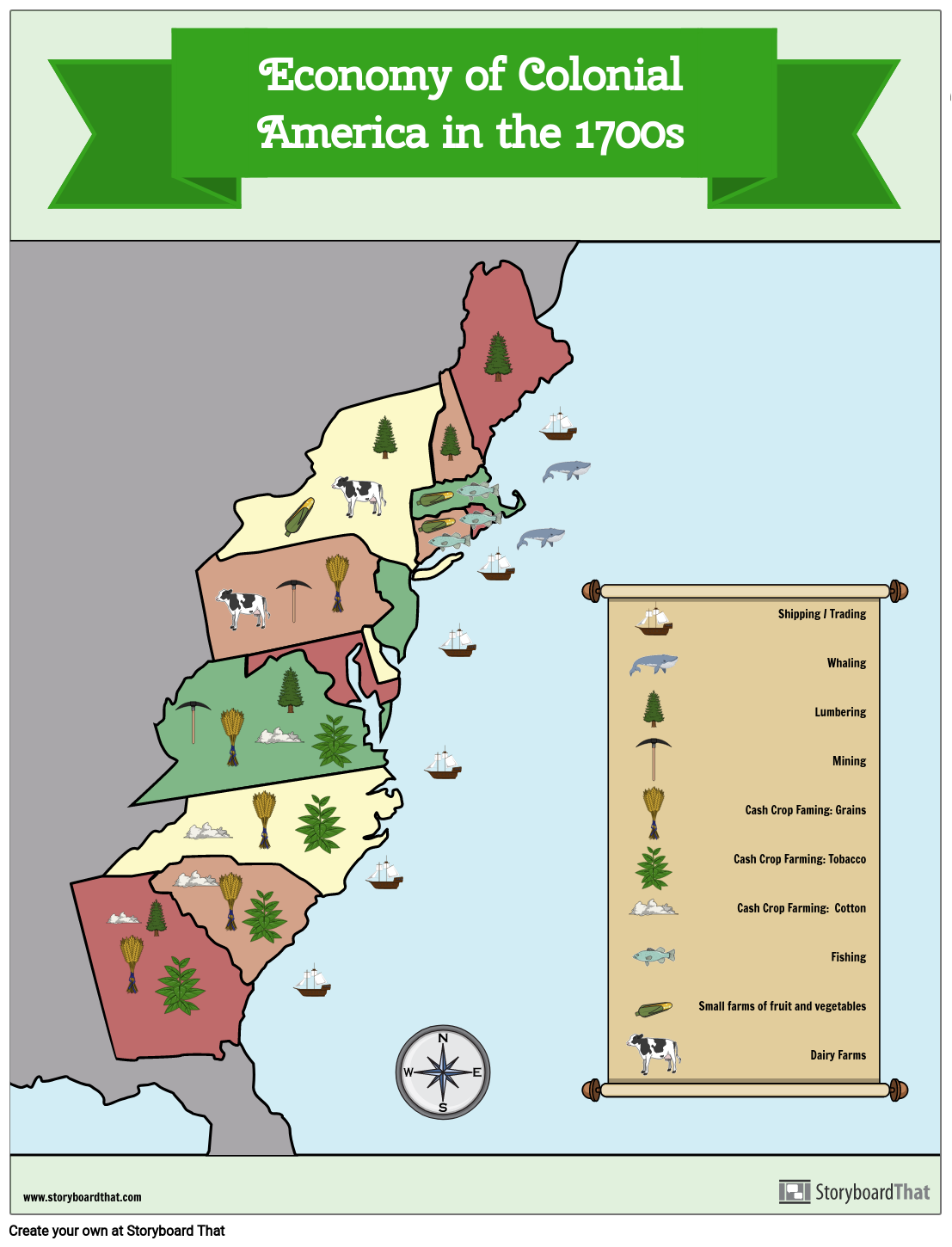
An economic map shows the specific types of economic activity present in an area using symbols to represent different industries. In this activity, students will create their own economic map for the 13 Colonies in the 1700s. This is a great way to help students remember the different jobs and industries that the colonists would have participated in.
They will choose images to represent different economic activity and then will place those images in the correct colonies. For example, students could put the image of a tobacco plant in Virginia to show that the cash crop of tobacco was a big part of Virginia’s economy in the 1700s. They will include a key at the bottom of the map that shows the symbol and uses text to tell what it represents.
Template and Class Instructions
(These instructions are completely customizable. After clicking "Copy Activity", update the instructions on the Edit Tab of the assignment.)
Due Date:
Objective: Create an economic map of Colonial America in the 1700s.
Student Instructions
- Learn about the different jobs and industries in the 13 colonies in the 1700s.
- Click "Start Assignment".
- Place images that represent different jobs and industries in the appropriate colony. For example, you could put the image of a tobacco plant in Virginia to show that the cash crop of tobacco was a big part of Virginia’s economy in the 1700s. You may repeat images in more than one colony.
- Create a key at the bottom of the map. Include the images that you used along with a short description of what it represents. For example, put the tobacco leaf in the key and next to it write “Tobacco Farming”.
Requirements: Must have at least one image in each colony that represents an industry that was present in the 1700s. Also, must have a key to show what each image symbolizes.
Lesson Plan Reference
Student Rubric
(You can also create your own on Quick Rubric.)
| Proficient | Emerging | Beginning | |
|---|---|---|---|
| Written Work | If there is writing, it is clear and uses complete sentences. | If there is writing, it is somewhat clear and uses some complete sentences. | If there is writing, it is incomplete and unclear. |
| Illustrations | The illustrations represent the assignment using appropriate scenes, characters and items. | The illustrations relate to the assignment, but are difficult to understand. | The illustrations do not clearly relate to the assignment. |
| Evidence of Effort | Work is well written and carefully thought out. | Work shows some evidence of effort. | Work shows little evidence of any effort. |
| Conventions | Spelling, grammar, and punctuation are mostly correct. | Spelling, grammar, and punctuation are somewhat correct. | Spelling, grammar, and punctuation are mostly incorrect. |
How to Teach About Colonial Economics Through Role-Playing Games
Setting the Stage for Colonial Economics
Begin by introducing students to the economic concepts relevant to the 13 Colonies, such as trade, agriculture, and goods production. Use maps and visuals to highlight the geographical locations of the colonies and their economic specialties (tobacco in the South, shipbuilding in New England, etc.). Explain the concept of role-playing and how it can help understand historical contexts.
Assigning Roles and Preparing the Game
Assign students different roles that were common in the colonial period, such as farmers, artisans, merchants, and colonial governors. Provide a brief description of each role, including their economic activities and their importance in the colony. Prepare the classroom to simulate a colonial marketplace. This could involve setting up different 'stations' representing various colonies and their economic outputs.
Conducting the Role-Playing Game
Begin the role-playing session. Students in the role of merchants and traders move between stations to 'buy' and 'sell' goods (using fake currency or barter system). Farmers and artisans 'produce' goods, while governors oversee trade regulations and collect taxes. Encourage students to negotiate, barter, and make decisions as per their roles. This activity helps them understand the dynamics of colonial trade, the value of different goods, and the challenges of economic life in the 1700s.
Debrief and Reflect on the Experience
After the role-play, lead a debriefing session. Ask students to reflect on their experiences, what they learned about colonial economics, and how different roles contributed to the economy. Discuss the impact of colonial economics on modern American economic practices. Highlight key takeaways about supply and demand, trade relationships, and economic specialization.
Frequently Asked Questions about Economies of the 13 Colonies Map Activity
How did geography influence the economy of each colony?
Geography played a crucial role in shaping the economies of the 13 Colonies. In the Northern colonies, the colder climate and rocky terrain limited agricultural potential but encouraged the growth of industries like shipbuilding, fishing, and later manufacturing. The Middle Colonies, with more fertile soil and a moderate climate, became known for their diverse agriculture, especially grain production. In contrast, the Southern Colonies, benefiting from a warmer climate and fertile land, developed economies based on large plantations growing cash crops like tobacco, rice, and indigo. Proximity to rivers and coastlines in many colonies facilitated trade and transportation. Thus, the specific geographic features of each region directly influenced the type of economic activities that were most feasible and profitable.
How were the economies of the Northern and Southern Colonies different?
The economies of the Northern and Southern Colonies differed primarily due to their distinct geographic and climatic conditions. The Northern Colonies, particularly New England, had a diversified economy that included small-scale farming, fishing, shipbuilding, and, later, manufacturing. This diversification was partly due to the less fertile soil and harsher climate, which made large-scale agriculture less viable. In contrast, the Southern Colonies' economy was heavily agrarian, with large plantations centered on cash crops like tobacco, rice, and indigo. This was facilitated by the region's warm climate and fertile soil. The Southern economy was also heavily reliant on slave labor, in contrast to the North, where slavery played a less significant role.
How can storyboards be used to illustrate the role of natural resources in the economies of the 13 Colonies?
Storyboards can be an effective tool to visually illustrate the impact of natural resources on the economies of the 13 Colonies. They can be used to create sequential art that depicts how specific resources were harvested and used. For instance, a storyboard could illustrate the process of tobacco cultivation in Virginia, highlighting how the fertile soil and warm climate were ideal for this crop. Another panel could show the timber and fish resources in New England, depicting the forests and coastal scenes, and linking them to shipbuilding and fishing industries. By visually representing these activities, students can better understand the direct connection between a region's natural resources and its predominant economic activities. Storyboards can also incorporate key facts and figures, making the information engaging and easily digestible.
More Storyboard That Activities
13 Colonies
Testimonials

“By using the product, they were so excited and they learned so much...”–K-5 Librarian and Instructinal Technology Teacher

“I'm doing a Napoleon timeline and I'm having [students] determine whether or not Napoleon was a good guy or a bad guy or somewhere in between.”–History and Special Ed Teacher

“Students get to be creative with Storyboard That and there's so many visuals for them to pick from... It makes it really accessible for all students in the class.”–Third Grade Teacher
© 2025 - Clever Prototypes, LLC - All rights reserved.
StoryboardThat is a trademark of Clever Prototypes, LLC, and Registered in U.S. Patent and Trademark Office


