Lesson Plan Overview
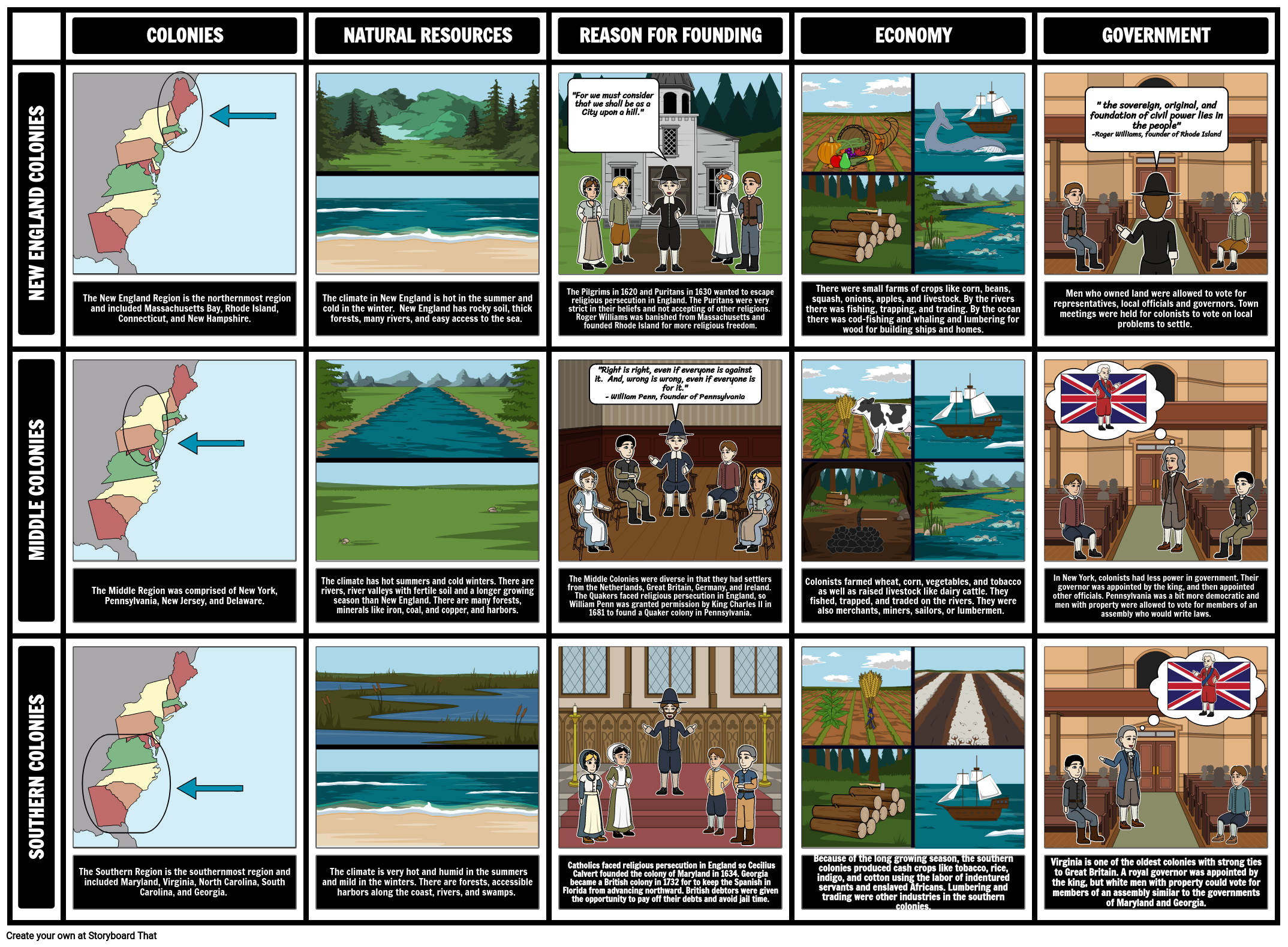
In order to help students keep track of each colonial region and their foundations, it can be helpful to organize information into a chart. In this activity, students will create a compare and contrast chart to display their understanding of each region's geography, resources, economy, demographics, and government.
See Colonial Regions for an activity for a single region.
Students Can Collaborate!
Teachers may wish for students to work together on this lesson which is possible with Storyboard That's Real Time Collaboration feature! With Real Time Collaboration, students can work on the same storyboard at the same time which is perfect for this lesson! As teachers know, collaborating on assignments allows students to think on a deeper level while increasing their communication and problem-solving skills. Collaboration can also help cut down on the time it takes to complete a storyboard. While there is no set limit to the number of users who can work on a storyboard at once, we recommend five users or fewer for optimal performance. All of our assignments default to individual. To make this lesson collaborative, teachers must enable collaboration for the assignment within the "Edit Assignment" tab.
Template and Class Instructions
(These instructions are completely customizable. After clicking "Copy Activity", update the instructions on the Edit Tab of the assignment.)
Due Date:
Objective: Compare and contrast the natural resources, the economies, demographics and governments of the American colonial regions in the 1700s.
Student Instructions:
- Click "Start Assignment".
- In the description boxes, write: where the colonial regions are located and which colonies are included, the natural resources, reasons for founding (why did colonists come to these regions) and the types of local governments they created.
- Create an illustration for each cell using appropriate scenes, characters, and items.
Lesson Plan Reference
Student Rubric
(You can also create your own on Quick Rubric.)
| Proficient 33 Points | Emerging 25 Points | Beginning 17 Points | |
|---|---|---|---|
| Descriptions of Geography, Demographics, Economy and Government | Text includes one to two sentences that clearly and accurately describe the: Geography, Demographics, Economy and Government for the Colonial Region(s). | Text includes descriptions for most of the: Geography, Demographics, Economy and Government for each of the Colonial Region(s). | The text fails to describe most of the categories clearly and accurately. |
| Storyboard Image and Effort | Student uses appropriate symbols and illustrations to clearly convey the meaning of the text in each cell. | Student uses appropriate symbols and illustrations to clearly convey the meaning of the text in most of the cells. | Student does not clearly convey the meaning of the text in the cells through the symbols or illustrations. |
| Spelling and Grammar | Student uses exemplary spelling and grammar. There are no errors. | Student makes one or two minor errors in spelling and grammar. | Student makes multiple errors in spelling and grammar. |
How to Use Role-Playing to Deepen Understanding of Colonial Differences
Introduction to Colonial Roles and Regions
Start with a brief overview of the three main colonial regions (New England, Middle, and Southern Colonies), highlighting their unique geographical features, economies, and social structures. Introduce the concept of role-playing and explain how it can help students understand the perspectives of people living in different colonial regions.
Assigning Roles and Research
Assign students different roles that would have been typical in the colonial era, such as a New England shipbuilder, a Middle Colony artisan, or a Southern plantation owner. Provide time for students to research their roles, focusing on how their character's life would have been influenced by the geography, economy, and social norms of their region.
Role-Playing Scenarios
Set up role-playing scenarios where students interact based on their assigned roles. These scenarios could include a town meeting, a market day, or a debate on a colonial issue. Encourage students to speak and act in ways that reflect their character's background and regional characteristics. For example, a farmer from the Southern Colonies might discuss issues related to plantation agriculture, while a merchant from the Middle Colonies might talk about trade.
Debrief and Reflect
After the role-playing session, lead a debriefing discussion. Ask students to reflect on their experiences and share what they learned about life in their specific colonial region. Facilitate a discussion on how regional differences led to diverse ways of life and viewpoints within the colonies. Encourage students to consider how these differences might have contributed to future historical events, such as the American Revolution.
Frequently Asked Questions about Compare and Contrast the 13 Colonies
How did social and cultural life differ among the 13 Colonies?
Social and cultural life in the 13 Colonies varied significantly, shaped by geographic, religious, and economic factors. The New England Colonies, largely influenced by Puritanism, had a more homogenous society with a strong focus on community and religious conformity. Education and town meetings played significant roles here. The Middle Colonies were characterized by their diversity, with settlers from various European backgrounds and a range of religious practices, leading to more tolerance and cultural plurality. The Southern Colonies, with their plantation-based economy, had a more stratified society. The large plantations, worked by enslaved Africans, created a social hierarchy with a distinct gentry class. Cultural practices in these regions were also varied, reflecting the differences in lifestyle, religious observance, and community structures.
How did the approach to governance and political organization vary among the colonies?
The approach to governance and political organization in the colonies reflected their diverse origins and purposes. New England Colonies, particularly Massachusetts, initially practiced a theocratic system with the church heavily influencing governance. However, they also developed early forms of democratic participation, like town meetings. The Middle Colonies, especially Pennsylvania under William Penn, were known for liberal policies, religious tolerance, and representative assemblies. The Southern Colonies typically had a more aristocratic structure, with power concentrated among the plantation-owning elite and county governments playing a significant role. Despite these differences, all colonies operated under charters or grants that outlined their relationship with the British crown, and over time, they developed a stronger sense of self-governance and autonomy.
What are some creative ways to design worksheets that compare and contrast colonial life?
Designing creative worksheets to compare and contrast colonial life can involve various interactive and thought-provoking elements. One approach is to use Venn diagrams where students can visually map out the similarities and differences between two or more colonies. Timelines can be employed to contrast the development of social and political structures over time. Worksheets with role-play scenarios can encourage students to imagine life in different colonies, enhancing empathy and understanding. Comparative tables or charts are useful for organizing information on various aspects like economy, religion, and governance. Including primary source analysis, such as excerpts from historical documents, can provide students with a direct view of life in the colonies. Creative writing prompts, such as diary entries or letters written from the perspective of a colonial inhabitant, can also be an engaging way for students to demonstrate their understanding of the different colonial lifestyles.
More Storyboard That Activities
13 Colonies
Testimonials

“By using the product, they were so excited and they learned so much...”–K-5 Librarian and Instructinal Technology Teacher

“I'm doing a Napoleon timeline and I'm having [students] determine whether or not Napoleon was a good guy or a bad guy or somewhere in between.”–History and Special Ed Teacher

“Students get to be creative with Storyboard That and there's so many visuals for them to pick from... It makes it really accessible for all students in the class.”–Third Grade Teacher
© 2026 - Clever Prototypes, LLC - All rights reserved.
StoryboardThat is a trademark of Clever Prototypes, LLC, and Registered in U.S. Patent and Trademark Office


